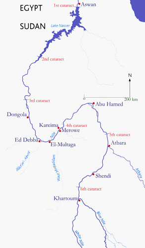
 Aswan
AswanAswan is Egypt's southern most City and has a population of 150,000. In Ancient Egypt it was a frontier town just above the 1st Cataract between Egypt and Nubia. It has a fine museum, Nubian Museum ,which opened in 1998 and is partially sponsored by UNESCO.
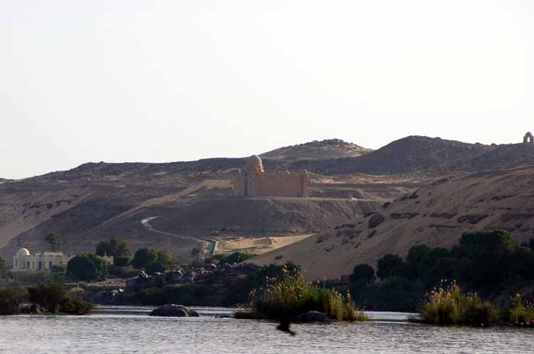
One of the famous landmarks at Aswan is the Mausoleum of the Aga Khan. It was modelled on the Fatimid tombs in Cairo, it has an open court which culminates in a Carrara marble Mihrab and sarcophagus, enshrining Aga Khan III - the 48th Imam of the Isma'ili sect of the Shi'te Muslims. The Aga Khan was, for his diamond jubilee in 1945, weighed in jewels. After his death in 1957 pilgrims flocked to Aswan, their camps posed such a health hazard the Egyptian government had to ban the mass pilgrimages. The Aga Khan was attracted to Aswan because of the climate and hot sands, which eased his rheumatism.
The area now known as Nubia extends along the Nile from south of Aswan to Dabba near the 4th Cataract. Nubia's name is first mentioned in Strabo's Geographia. He was a Greek who is thought to have visited Egypt in 29 BC. The name Nubia's origin is not certain but many agree that it originates from the Ancient Egyptian word nbu, meaning Gold - Nubia had many gold mines which Egypt depended on for it's wealth. However the name does not appear in any Ancient Egyptian text, which refer to Nubia as Ta-Seti, meaning "Land of the Bow."
Ancient Egyptians always distinguished Lower Nubia between the 1st and 2nd cataracts (which they named wawat) from the area south of the 2nd cataract which they named Kush. The Nubians settled and lived along the Nile and were distinct from the semi-nomadic tribes who lived in the eastern dessert (between the Nile and the Red Sea).
Owing to it's unique location Nubia was a major trade route through which exotic African goods reached Egypt. These included ebony, ivory, ostrich feathers and eggs and people. Nubia is rich in gold, copper and semi-precious stones such as carnelian, jasper and amethyst.
"Mother" Nile is Egypt's main highway. Boats can either float or row north with
the current, or sail south- using the predominant north winds. Aswan was
considered the southern frontier of Egypt, since navigation was blocked by
cataracts to its the south. From garrisons situated in Aswan, military missions
could be launched to subdue the Nubians. Trading missions into central Africa
left from and returned to this point, sending their trade goods by ship
down-river to Memphis or Thebes.
 To make it possible for his ships to sail beyond Aswan, Merenra (ruled
2287-2278, 6th Dynasty) ordered a channel excavated through the rapids. The
official he sent to supervise the task left a record of the work in his tomb,
while the Merenra visited and left two inscriptions commemorating his visit. The
channel had to be cleared anew in the reign of Senusret III (Khakaura, ruled
1870-1831 BC, 12th Dynasty) before he could undertake his conquest of Nubia.
Thutmose III (Menkheperra, ruled 1479-1425 BC, 18th Dynasty) ordered work on the
channels. This work wouldn't have involved excavation, the goal was to remove
some of the boulders and sediments brought down by the annual floods.
To make it possible for his ships to sail beyond Aswan, Merenra (ruled
2287-2278, 6th Dynasty) ordered a channel excavated through the rapids. The
official he sent to supervise the task left a record of the work in his tomb,
while the Merenra visited and left two inscriptions commemorating his visit. The
channel had to be cleared anew in the reign of Senusret III (Khakaura, ruled
1870-1831 BC, 12th Dynasty) before he could undertake his conquest of Nubia.
Thutmose III (Menkheperra, ruled 1479-1425 BC, 18th Dynasty) ordered work on the
channels. This work wouldn't have involved excavation, the goal was to remove
some of the boulders and sediments brought down by the annual floods.
19th century travellers found the trip through the cataract with their rented
houseboats, or dahabeyas, a memorable experience. Boats were pulled or winched
upstream, while the downstream ride through narrow channels filled with rushing
water was hair-raising.
The geological setting of Aswan is complex and there are a number of Different
Kinds of Rock. Igneous and Metamorphic rocks of the
deep-lying basement complex have been uplifted and exposed in this area. The
river has eroded the overlying Nubian sandstone and carved deep channels into
the igneous rocks. In addition to the island-choked channel of the present Nile,
there is evidence for at least two other ancient, but now abandoned, Nile
channels. The road leading north from the east end of the 1934 Dam follows
one channel through a narrow valley between Gebel Bas and Gebel Ibrahim. Another
channel lies to the east of Gebel Ibrahim, where one of the earlier, more
vigorous Niles carved a vast valley. This was probably the course of the
late-Miocene Eonile, since a deep gorge has been detected under the Pleistocene
sediments that fill it. This valley has new residential and
commercial development - a steel mill, fertilizer factory and other industries
made possible by the High Dam's electric power output are located here.
Many visitors are unaware of this thriving and un-attractive complex. The
railroad from the north runs through the valley to the town of El-Shallal, which
was formerly the port for river steamers from Aswan to Wadi Halfa. A branch of
the railroad extends to the new port on the shore of Lake Nasser
beyond the High Dam.
Aswan's importance for the ancient Egyptians arose not only from its strategic
geographic location, but also from the variety of stone that could be quarried
locally and transferred easily to barges on the river. Sandstone forms the western
cliffs north of the 1934 Dam and survives atop the flat-topped hills of Gebel
Bas and Gebel Ibrahim. The reddish brown colour of the local sandstone is the
result of the high concentration of iron compounds that oxidize on their
surface. North-East of Aswan are deposits that provide iron ore for the Aswan steel
mills and at Helwan south of Cairo. This source of iron ore may have
been exploited as early as the New Kingdom, when the Egyptians learned about
iron working from the Levant. Prior to that they may have mined the red hematite
for pigments.
 Egyptian inhabitants of Aswan have different facial
characteristics. Some have strong profiles more in common with the south and are
proud to call themselves Nubian.
Egyptian inhabitants of Aswan have different facial
characteristics. Some have strong profiles more in common with the south and are
proud to call themselves Nubian.
The softness of the sandstone in the escarpment of Gebel Qubbet el-Hawa on the
west bank opposite Aswan encouraged Old and Middle
Kingdom governors to build rock-cut tombs there. Some of the sandstone cliffs have been altered into an extremely hard quartzite. This was quarried
in pharaonic times to provide material for statues and sarcophagi, several
examples are in Luxor. For example, the carved sarcophagus in
the tomb of Tutankhamun is carved from dark red quartzite.
A large variety of igneous and metamorphic rocks are found among the numerous
outcroppings of basement complex around Aswan, but only a few kinds of rock were
exploited extensively in ancient times. Red or pink granite and grey
granodiorite are the most prominent. Nearly 100 quarrying sites have been identified on the east bank and the islands.
Many natural granite boulders still lie in heaps along the roads and riverbanks.
Granite was a popular stone among the Old Kingdom kings. It was used to
construct the burial chamber at the Saqqara Step Pyramid in the 3rd Dynasty.
4th Dynasty kings used it lavishly in their burial chambers and in their
mortuary temples at Giza. King Djedefre (Radjedef, ruled 2566-2558 BC, 4th
Dynasty), Khafra (Chephren, ruled 2558-2532 BC,
4th Dynasty) and Merenra (ruled 2287-2278 BC, 6th Dynasty) had one or more
courses of granite casing on the outside of their pyramids. Granite was also
used for sarcophagi and portcullises to seal the pyramid passageways. During the
5th Dynasty, granite portcullis chambers continued to be built in limestone
pyramids.
Granite was surely preferred over other stone for some of these applications
because of its greater hardness. In addition, its appearance may have been a
consideration. Both red granite and black or grey granodiorite were used; they
take a fine polish and the colours may have had a special symbolism in
certain applications. For whatever reason it was chosen over other stones,
granite was much more difficult to work than either of the other far more common
building materials, limestone and sandstone. Many theories abound about how the ancient Egyptians must have had
advanced techniques for working hard stones and how knowledge of these
techniques has since been lost. There is no evidence for any unknown methods and
much evidence for the methods actually used, which mostly involved physical strength
and time.
Most of the granite employed during the Old Kingdom was probably not quarried in
the sense of extracting a block from a great mass of mother rock. Instead
naturally formed blocks were used; all that was necessary was to select a block
of appropriate size, load it onto a barge for shipment downriver, and finally
shape it. Judging from unfinished examples left in the quarries, preliminary
shaping was done at Aswan to reduce the weight.
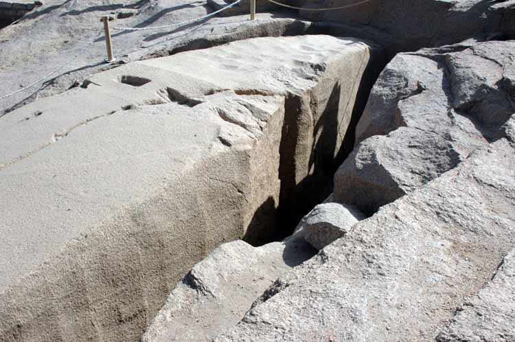 Unfinished Obelisk
- one of the red granite quarries
that provided stone for Ancient Egyptian temples and statues still holds a giant
and unfinished obelisk. The obelisk is roughly dressed
and was in the process of being 'cut free' of the surrounding rock. A flaw in
the stone developed, which is still very visible, and the work was abandoned. It
is thought that this was the pair of the Lateran Obelisk, which is now in Rome,
which originally stood before Karnak Temple and was commissioned for Tuthmosis
III.
Unfinished Obelisk
- one of the red granite quarries
that provided stone for Ancient Egyptian temples and statues still holds a giant
and unfinished obelisk. The obelisk is roughly dressed
and was in the process of being 'cut free' of the surrounding rock. A flaw in
the stone developed, which is still very visible, and the work was abandoned. It
is thought that this was the pair of the Lateran Obelisk, which is now in Rome,
which originally stood before Karnak Temple and was commissioned for Tuthmosis
III.
From the chisel marks and the ancient tools found in the area, some of the ancient quarry techniques have been determined. These include soaking wooden blocks to encourage the rock to crack and also using quartz sand slurry as an abrasive. The huge effort required to free this Obelisk is staggering, especially considering the basic tools and lack of any non-manual techniques. If the piece was freed an equally monumental effort would have been needed to move it 220 Km from the Quarry to the Nile, and then to Karnak.
Granite naturally weathers into conveniently-shaped boulders. Granite forms from
molten magma as a great solid mass far underground. As this mass cools and
solidifies it is typically under great pressure. Tectonic movements may
eventually lift this mass closer to the surface. As the land above this granite
mass erodes, the external pressure on the mass is reduced and the granite begins
to fracture along horizontal and vertical planes at right angles-an action known
as pressure release. This produces joints that define nearly perfectly
rectangular blocks. Tectonic forces can also crush and fracture the rocks.
Slightly below ground, in a humid environment such as Egypt experienced in times
past, the blocks weather along the joints into more rounded shapes. Then when
the rocks are exposed by erosion of the overburden, the blocks are revealed
ready for use without the difficulties attendant to quarrying them. The role of
the river is primarily to expose the rocks, but some rounding may also occur
when the floodwaters sweep debris over the surface of the boulders.
After selecting a granite boulder of the right size Egyptians used a
number of techniques to smooth it. These included hitting it with
Dolerite hammer stones and sawing or drilling using copper saws and
drill bits in conjunction with fine sand. All of these would be slow,
time-consuming operations, but each would eventually produce the desired
results.
The already jointed granite blocks probably served many of the purposes of the
Old Kingdom, such as casing blocks and wall blocks in chambers and temples; even
pillars and roofing beams could be made from larger stones. But when demands
exceeded the size of the available boulders, quarrying became necessary. The obelisks and colossal royal statues popular in the Middle and New Kingdoms
had to be derived from a larger, solid mass of rock.
Evidence of the methods the Egyptians used to do this can still be seen on the
famous 'unfinished obelisk' - if completed it would have been almost 42 m tall and weighed
over 1,100 tons. Along each
side of the obelisk are trenches formed by overlapping shallow depressions-each
one revealing where a worker stood and hammered on the granite with a Dolerite pounder, a ball of stone weighing 4 or 5 kg (around 10 pounds). The reason that
this obelisk was abandoned after months of work is obvious: an enormous crack
stretches across the top.
In the Aswan quarries, and on many sites throughout Egypt where granite was
employed anciently, one can see granite blocks with a series of rectangular
holes defining the line along which the block is to be split. It is sometimes
asserted that wooden wedges were inserted into these holes and soaked with water
until they swelled and split the rock. Recent experiments with wetted wedges
show that they would not have been effective in splitting granite. The holes
themselves must have been cut using iron or steel chisels, which only became
available in Egypt in the Late Period and widespread in Greco-Roman times. In
these classical times, iron wedges and possibly splints were used after a series
of rectangular holes had been cut. Where employed, two splints (also called fins
or feathers) in the form of two flat metal plates were placed into the holes,
and the wedge was placed between them. The splints served to direct the force of
the wedge horizontally against the sides of the holes rather than allowing it to
be driven into the rock at the bottom of the hole. These methods of rock
splitting are still in use today. Many of the holes seen in granite blocks on
archaeological sites may date from an even more recent period and be the work of
modern stone robbers.
 Once a granite block had been quarried, it was moved to a dock on the Nile along
a series of specially constructed roadways and transferred to a boat to be
floated down the Nile to a building site such as Giza. Travellers visiting Giza
can look at the way in which these granite blocks were incorporated into
buildings. When granite was used for casing blocks on a pyramid or to line the
walls of a temple, only the block's sides, top and bottom, and front were
dressed. On the backside, the softer limestone backing-stones were cut to accept
the natural curves of the granite blocks. Examples of this can be seen on
Khafra's pyramid, where several casing blocks remain in place, and in the Khafra
valley temple and Merenra mortuary temple, although most of the granite
originally placed in those temples has since been stripped away. We can also see
that the casing blocks on Merenra's pyramid have been set in place with their
edges reduced to the final face angle, but excess material (in fact the natural
curve of the block) left in the centres.
Once a granite block had been quarried, it was moved to a dock on the Nile along
a series of specially constructed roadways and transferred to a boat to be
floated down the Nile to a building site such as Giza. Travellers visiting Giza
can look at the way in which these granite blocks were incorporated into
buildings. When granite was used for casing blocks on a pyramid or to line the
walls of a temple, only the block's sides, top and bottom, and front were
dressed. On the backside, the softer limestone backing-stones were cut to accept
the natural curves of the granite blocks. Examples of this can be seen on
Khafra's pyramid, where several casing blocks remain in place, and in the Khafra
valley temple and Merenra mortuary temple, although most of the granite
originally placed in those temples has since been stripped away. We can also see
that the casing blocks on Merenra's pyramid have been set in place with their
edges reduced to the final face angle, but excess material (in fact the natural
curve of the block) left in the centres.
In the first half of the AD 20th century, Aswan granite was used to build the
series of Aswan dams designed to store part of the floodwater for summer
irrigation. The water level in the lake behind the dam rose in the late fall as
the last stages of the floodwater were retained, then it dropped in the summer.
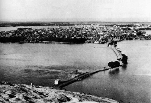
The island of Philae was just upstream of the dam, and the splendid sandstone
temples on it were submerged for nine months each year. In the early 1900s,
methods of protecting the monuments were discussed. Removal to another site was
considered, but it was felt this would destroy the essential context of the
temples, so they were left in place. The fragile sandstone was reinforced,
however, which turned out to be a crucial decision, since this protected the
blocks against the erosive action of the water for almost seventy years. The
plans for the High Dam called for the sluice gates in the 1934 dam to serve as
regulators of the discharge into the river. As a consequence, the island of
Philae would be permanently submerged. Again the question of how to pre-serve Philae's monuments was raised, and the plan of building a coffer dam around the
island to hold out water was adopted first. It soon became clear, however, that
such a dam could not be relied on and that relocation was the best solution.
Nearby Agilka Island was selected as the new site; its granite peak was
excavated and rubble dumped around its edges to create a topography that more
closely resembled the original Philae. The more than 37,000
blocks were recorded, disassembled, cleaned of seventy years' worth of silt and organic
incrustations, and reassembled in their new home. Work began in September 1975;
it took eighteen months to dismantle the monuments and another two years to
rebuild them.
When the High Dam was being designed, it was expected that the granite
outcropping above the First Cataract and in the cliffs would form an excellent
impermeable substrate for the massive dam. But when engineers bored test holes
into the river bottom, they discovered a huge sediment-filled gorge extending
more than 250m below the modem Nile channel. In the early 1960s no one could
explain how such a deep canyon had been formed. When the late-Miocene
desiccation of the Mediterranean was proposed in 1970, the mystery of the Nile
Canyon was solved.
In order to accommodate itself to the site, the High Dam was designed as a
massive rock-fill gravity dam structure. It is 980m (or almost a kilometer)
thick at its base and rises 111m from the riverbed to a crest 40m wide. Its
volume is equivalent to seventeen Great Pyramids. In fact, the north-south
cross-section of the dam resembles a pyramid, with two wings extending upstream
and downstream; these wings incorporate the cofferdams that were built on each
side of the construction site. To prevent water from percolating through the
sediments filling the gorge beneath the channel, a 'grout curtain' was formed by
pumping cement into deep holes bored to bedrock in a line across the entire
channel. The pumping pressure caused the cement to spread out and consolidate
the surrounding gravels, sands, and silts. This grout curtain is 60 m thick and
extends about 800m from the dam's core down to the granite bedrock. A
fascinating account of the dam's construction can be found in Little (1965). The
feasibility of the construction plan depended on the availability of local
materials (granite and sand) and a source of electric power at Aswan. The 1934
Aswan Dam did not include a hydroelectric power plant when it was first built,
but in 1961 one was constructed in it specifically to provide power for the High
Dam construction project.
Lake Nasser and Nubia
South of Aswan and part of northern Sudan comprised the ancient land of Nubia.
This desert land was sometimes dominated by Egypt, while at other times it
pursued an independent course, and once, in the Twenty-fifth Dynasty, a Nubian
family occupied the throne of the Egyptian. Nubians traditionally lived in small
villages along the river, where they pursued agriculture, fishing, and some
herding. They were also involved in the extensive trade between Egypt and
central Africa that passed along the river.
 Aswan (93m above sea level) was the logical place to build dams across the
Nile, since boats could not ascend farther because of the cataracts and since
the floodplain narrowed significantly along the Nubian stretch of the river. The
first three dams at Aswan (actually one dam enlarged two times) were only
intended to store the water of one flood season and release it at the next low
water. They created reservoirs with increasing heights: the 1902 dam raised a
lake to 106m above sea level, the 1912 dam to 113m, and the 1934 dam to 121m.
Aswan (93m above sea level) was the logical place to build dams across the
Nile, since boats could not ascend farther because of the cataracts and since
the floodplain narrowed significantly along the Nubian stretch of the river. The
first three dams at Aswan (actually one dam enlarged two times) were only
intended to store the water of one flood season and release it at the next low
water. They created reservoirs with increasing heights: the 1902 dam raised a
lake to 106m above sea level, the 1912 dam to 113m, and the 1934 dam to 121m.
The High Dam at Aswan was completed in 1970, and since then the water of the
Nile has collected to form the 500 km long Lake Nasser. The lake averages about
10 km in width, but bays extending up into former wadis make its outline very
irregular. When the lake is filled to its maximum level of 175m above sea
level, the reservoir holds nearly 140 billion cubic meters of
water. The level rises and falls as floodwater is retained and then released
over the course of the year.
From 1900 to 1960, the yearly flow of the Nile averaged about 84 billion cubic
meters of water, but there was considerable year-to-year variation. Based on
this historical average, a 1959 treaty allotted Egypt 55.5 billion cubic meters
per year from Lake Nasser and Sudan 18.5 billion; the final 10 billion cubic
meters was allotted to evaporative losses.
One disadvantage of the Aswan location for the High Dam is that the dry desert
air evaporates a great deal of water from the surface of Lake Nasser. Yearly
evaporation and seepage losses average about 10% of the volume of water in the
reservoir. Seepage is expected to decline, however, as neighbouring aquifers
become saturated. Since the dam traps all the floodwater, it also traps the
suspended materials carried by the flood. This amounts to around 110 million
tons each year. The coarse sediments collect at the south end of the lake in the
vicinity of the Second Cataract, where the lake is already shallow. These
sediments have accumulated to the point of emerging as islands above the
surface. The designers of the dam anticipated that silts and clays would
accumulate, how-ever, and allocated 20% of the lake's volume to hold
them. This provision should accommodate the sediments for 400 to 500 years.
The scenery along Lake Nasser is less dramatic than that of the former Nubian
Nile, but one has a better view of the landscape beyond the river. The surface
of the desert on each side of the Nile is a plain with an elevation of around 20m above the lake, or around 200m above sea level. This plain is deeply incised
with wadis entering from both the east and the west. Beyond the
first plain are two others stepping back to the west and east at elevations
above sea level of 230 to 260m for the first stage and 300 to 360m for the
highest level. The surface of the two lower plains is made of Nubian sandstone,
while the surface of the highest plain (consisting of younger rock) is composed
of Cretaceous limestone and shale. To the far west of the lake an escarpment of
Eocene limestone, the Sinn el-Kaddab, marks the southeast edge of the vast
limestone plateau that separates the oases of the Western Desert from the Nile
Valley.
These three plain surfaces at successively higher elevations are called pedi-plains and were formed by earlier cycles of erosion. A pedi-plain is an
erosional surface characteristic of arid environments. Its formation can be
explained as follows. Suppose one begins with a plateau at some elevation above
sea level. Rain falling on the plateau will flow into streams that will begin to
cut channels into the surface of the plateau. These channels will gradually
widen until the plateau is dissected into a series of isolated buttes surrounded
by a plain whose elevation is equal to that of the base level of the
drainage-either sea level, or in this case since we are far inland, the level of
the river into which the wadis drained. The isolated buttes will continue to
erode by undercutting, rock falls, and wind deflation.
If the base level falls, another cycle will begin with down-cutting of the plain
formed in the first cycle. After several cycles of this, a series of remnant
plains each studded with higher remnant peaks or tablelands will be formed.
Since such a process would be very slow in a hyper-arid climate with only
occasional cloudbursts, we probably have to look back to a time when the climate
of Egypt was much wetter-the Pleistocene or even much earlier-to have produced
the cycles of down-cutting just described. In the deserts today, the process
continues slowly 'nibbling' away at the residual higher peaks.
Recently the formation of the Nubian pedi-plain landscape has been linked to a
proposal for a river system that preceded the Nile called the Qena River
(pronounced Gena). This
was a south-flowing river that existed during the Miocene from about 24 to 6
million years ago. This new proposal asserts that repeated uplifts of the region
in connection with the opening of the Red Sea, rather than drops in base or sea
level, maintained the elevation differential that led to the cycles of
down-cutting.
Several of the wadis whose mouths now form bays along Lake Nasser have
interesting histories. The Kalabsha Wadi extends westward for nearly 100 km;
today the lake waters penetrate about 10 km into this depression. In 1981, a
magnitude 5.3 (on the Richter Scale) earthquake centred on this area raised
fears that the weight of the lake's water was the cause. A study showed that the
quake was associated with a previously existing east-west fault. The study
concluded, however, that the Aswan High Dam could withstand any disturbance
that was likely to occur.
Wadi Toshka (or Tushka) is 34 km northeast of Abu Simbel. It assumed a new
importance when it was decided to construct a spillway through it to divert
excess lake water rather than releasing it at Aswan and letting it sweep
downstream. Archaeological and geological surveys were conducted in preparation
for digging the channel. It was determined that this wadi had
once carried water from lakes in the Kiseiba-Dungul Depression to the Nile.
Within the wadi the investigators found a channel incised into bedrock but now
filled with sediment and covered with wind blown sand. The extreme depth of the
channel indicated it had probably been carved during the late-Miocene
Mediterranean desiccation, when the Nile was cutting its own canyon. Primitive
flint implements among the upper layers of sediments indicated that humans
might have lived along this stream as much as 200,000 years ago.
In the 1970s, the Sadat Canal was excavated through the sediments at the west
end of the wadi to open a route for excess water to flow into the Kiseiba-Dungul
Depression. In September 1996, when Lake Nasser's water level reached 178m
above sea level during an unusually high flood season, overflow water entered
the depressions at the west end of the canal and began to form several lakes.
Several more years of higher than average floods followed, so that by the year
2000 the Toshka Lakes occupied around 1600 sq km and held 20 billion cubic
meters of water.
Wadi Toshka may have been an important route to a hard stone quarry about 70 km
northwest of Abu Simbel. The quarry lies in an outcropping of the basement
complex rock and was worked from Predynastic times to the Middle Kingdom. It
provided the attractive anorthosite gneiss that was used for statues such as the
famous Chephren (Khafre) with the falcon on his chair in the Egyptian Museum.
During the Middle Kingdom, a road consisting of a cleared pathway was
constructed for a distance of 80 kilometers to the Nile Valley at Toshka.
In 1997, construction of the Sheikh Zayed (former Ruler of United Arab Emirates,
fiefdom of Abu Dhabi, family based in Al Ain) Canal was begun, leading from a point
on the west bank of Lake Nasser just north of Wadi Toshka. This canal is
designed to convey 5 billion cubic meters of water a year to the New Valley
Project (now also known as the Toshka Project) in the depressions of the Western
Desert. The water for the canal will have to be pumped up an average of 21 to
53m to get across the intervening section of the Nubian Plateau.
Wadi el-Allaqi enters Lake Nasser from the east 125 km south of Aswan. The
wadi's main channel is over 350 km in length. This channel and its major
tributary, Wadi Gabgaba, along with hundreds of lesser tributaries, drain an
area of the Nubian Desert estimated at 44,000 sq km. These must have been a
major source of the Nile's water during earlier periods of wetter climates
before the connection to the sub-Saharan sources (White and Blue Niles) was
established. Even in these hyper-arid times, an occasional thunderstorm in the
region will convert the wadi into a raging torrent. In 1830, Linant de
Bellefonds, a Frenchman employed by Muhammad Ali, reported that a flood from the
Wadi el-Allaqi was so strong that it prevented his dahabeya from sailing past
the confluence of the wadi and the Nile. Historically, Wadi el-Allaqi was
important to Egyptian society as the location of several productive gold mines.
One of these at Umm Qareiyat continued to be mined into the 1900s.
Antiquities along Lake Nasser
Lake Nasser has obliterated the original Nile Valley south of Aswan. Modern impressions of the valley's former appearance must be gained from the
archaeological reports of those who conducted salvage expeditions or from the
far more colourful journals of nineteenth and early twentieth-century
travellers. Once south of the Aswan cataract, boats formerly cruised between
high sand-stone cliffs that rose several hundred feet above the river. At
Kalabsha, 60 km south of Aswan, granite cliffs appeared and constricted the
gorge to a width of only 200 m for a distance of nearly 5 km. Elsewhere, narrow
floodplains supported small villages and some agriculture. Travellers such as
Amelia Edwards (1888) described the lively village activities, the appearance of
the monuments choked by sand, and the desolate expanses of desert. At Wadi Halfa
on the Egypt-Sudan border and 345 km south of Aswan, the Second Cataract began
and continued for nearly 200 km. Most travellers ventured no further. All of
this picturesque scenery and many archaeological sites now lie beneath the
waters of Lake Nasser.
In fact, the dams built at Aswan in the early decades of the twentieth century
began the obliteration of Nubia. As the water impounded by these dams inundated
riverbanks upstream, the Nubian villagers were forced to move their homes to
higher levels or move away. When the High Dam was completed, more than 60,000
Egyptian Nubians lost their homes. They were resettled in new villages
constructed for them east of Kom Ombo. Many were depressed at first by loss of
their traditional homes, riverfront way of life, and the failure of some
government promises to materialize. Gradually the resettled Nubians have been
more content, as farming opportunities have improved. While the younger
generation is becoming accustomed to the location, some of the elderly would
like to move back to the riverside.
Some archaeological salvage work preceded the 1912 and 1934 phases of dam
building, in order to excavate and record sites to be destroyed. In the late
1950s and early 1960s, an intensive international effort was mounted to record
as much as possible about sites-many heretofore unknown-that would be submerged
by the expanded lake. Like the Nubian people, some monuments were saved from
drowning by relocation. Since only a small number could be preserved, it must
have been an agonizing choice to decide which ones to save. And once chosen, the
fates of many were left hanging while a worldwide fundraising effort occurred.
The most incredible effort involved the relocation of the two rock-cut temples
at Abu Simbel. The project involved engineers, stonecutters, and archaeologists
from around the world. The $40 million cost was covered predominantly by Egypt
and the United States and by other funds raised by UNESCO.
The Abu Simbel temples, built by Ramesses II to honour himself and his wife,
were carved into a high cliff of Nubian sandstone on the west bank of the Nile
about 280 km south of Aswan. This site is now submerged beneath the waters of
Lake Nasser. To preserve the monuments, they were moved to a new site 65 m above
the old one and 210 m to the west. The original temple facade was carved into a
sandstone escarpment, while the interior was hollowed out of the cliff. The
Nubian sandstone has many cracks and fissures in it, the sand grains being only
weakly cemented together. While this made the work of carving the statues and
reliefs easier originally, it meant that they were easily worn. If the temples
had been placed anywhere but in an and environment like Nubia, they would have
been destroyed long ago. In the salvage operation, the fragile rock was
consolidated in many places prior to moving it.
The temples were relocated by first removing the overburden, that is, the
majority of natural rock above the temple, leaving only a thickness sufficient
to serve as a 'roof.' Then the temples were cut into blocks that were removed to
a storage area and later reassembled. The rebuilt Great Temple is covered by a
massive concrete dome 60m wide by 27m high. Built to sustain loads of 55 tons
per sqm, it is itself an engineering marvel that prevents the restored
overburden from resting directly on the temple interior. Work on the move began
in 1963 and was completed in 1968. In their new site, the temples retain their
original orientation, so that at sunrise on October 22 and February 22 the
sunlight still shines directly down the main aisle of the temple and illuminates
the sanctuary with its four gods: Re-Harakhte, Ptah, Amun-Re, and Ramesses
himself.
Other temples, tombs, and buildings from sites along the riverbanks were also
relocated. Being smaller it was possible to move them longer distances and group
several together in one place to create a series of destinations for travellers
cruising between Abu Simbel and Aswan. For example, a large temple with sections
dating from Amenhotep II to the Romans once stood on the riverbank at Kalabsha.
It was moved to a promontory just Southwest of the High Dam. This relocation
process was facilitated by the fact that the temple was built of 16,000 quarried
sandstone blocks and stood in the open rather than being cut into the cliff
face. The success of this move provided an example during later discussions
about the future of the monuments at Philae (see the next chapter). The blocks
for the Kalabasha Temple, like the other temples and tombs of Nubia, were
obtained at nearby sites, but these ancient quarries have also been inundated
and so are not available for study. When one visits the relocated monuments, one
is immediately struck by the deep reddish brown colour of the sandstone in the
structures and in the surrounding hills.
- Igneous rocks are formed when
molten rock, called magma, cools and solidifies. Sub-ducting
plates often form magma; the molten larva rises to the surface
where it cools and solidifies into Igneous rock. Igneous rock is
further defined as either intrusive (below ground) or
extrusive (above ground), depending whether it cools
underground or above ground. Intrusive igneous rocks happens
when magma cools below ground - the rate of cooling is slow
enough to form large crystals in each rock. Although they are
formed underground they are found on the surface by erosion or
magma up-welling. Extrusive (or volcanic) igneous rock
happens when magma, called lava, reaches the surface through
faults that feed volcanoes. Depending on its chemical
composition lava can be thick or thin, thin Lava can flow over
some distance on the surface and forms sheets.
Examples of Igneous Rock: - Andesite
- Anorthosite
-
Basalt
Diorite
Gabbro
Granodiorite
Porphyry - Sedimentary rock types can be
formed when old rocks are re-cycled by being broken up (not
melted). These are transported either by wind or water until
they rest in streambeds, river channels, floodplains, landlocked
basins, coastal lagoons or seafloor. They can become cemented
together by chemical process resulting from seawater or
percolation of rain. Common rock types include calcium
carbonate, silica (silicon dioxide) and iron oxide. Sedimentary
rock is characterised by the size of fragment and type of
cement. Sedimentary rock's properties are a function of
its fragments and cement. For example, sandstone varies in the
kind and quantity of cement ground, binding their sand grains.
As a result they vary in their hardness, which affects how well
they perform as building stone. In some sandstone the cement is
weak and the individual grains separate readily from their
neighbours; in others the cement may actually be tougher than
the material it holds together, so a, called that when the rock
breaks, it breaks across the grains.
One of the most important sedimentary rocks in Egypt is limestone. Limestone isn't defined by the size of its particles but by its chemical composition: both its grains and cement are composed of the compound calcium carbonate. Calcite and aragonite are common minerals containing this compound. Limestone forms in a variety of marine environments. Many marine organisms ranging in size from giant clams and other molluscs down to tiny proto-zoa extract calcium carbonate from seawater and use it to form external shells or internal skeletons. When these organisms die their shells or broken shell fragments sink to the bottom, where they may be lithified by calcium carbonate precipitating from saturated seawater or produced by other limestone-ground secreting organisms. The texture of limestone can vary from very coarse (when shell fragments are large) to very fine (when the grains are tiny or sand- sized). Limestone is generally considered a relatively soft rock (compared to and their granite, for example), but this is a function of the amount of calcium carbon-ate cement; some poorly cemented limestone are very friable or chalky, while other types are much harder. Limestone may contain considerable amounts of sand or clay (see marl). Its purity, texture, and hardness will determine limestone's suitability for use as a building stone, for statuary, or for other purposes.
Several other kinds of sedimentary rock consist entirely of minerals precipitated from mineral-rich seawater or evaporating pools; such rocks are very fine-textured. Flint (also known as Chert) is found within layers of some limestone in the form of seams or nodules. Such nodules form when silica replaces the calcium carbonate. Gypsum and halite (rock salt) are usually formed by evaporation; they consist of calcium sulphate and sodium chloride. Travertine forms when water saturated with calcium carbonate evaporates around a hot spring or in a cave to form stalactites and stalagmites.
Layers of sediment are usually horizontal when they are deposited; such a layer is called a stratum (plural strata) or a bed. Younger layers accumulate on top of older layers. These two facts have been referred to as the 'law of horizontality' and the 'law of superposition' of strata and are keys to an analysis of rock origins and dating. After sediments have become cemented into stone, tectonic events such as plate collisions may change their orientation-uplifting and tilting or even overturning blocks composed of many layers. Geologists learn to recognise these disturbances and use them as evidence to reconstruct past events. Younger rocks can also underlie older ones when magma rises into older rocks: the igneous rocks will be younger than their surroundings. The study of rock strata is an important branch of geology called stratigraphy.
If sediment continues to be deposited at a location and lithification (cementing) continues, the depth of the sedimentary rock will increase with time. As conditions change the kind of rock formed at a particular location will also change. For example, the kind and quantity of fragments deposit-ed by a river into an ocean depend on the conditions in its drainage basin; these conditions include the kinds of rocks exposed, the climatic conditions, the volume of water flowing, the slope of the river, and other factors. When the river meets the sea, coarse sediments, that is large particles, will be deposited close to shore, while fine particles will be carried out farther before they finally sink to the bottom. Deep basins will permit sediments to be deposited for longer periods, building up thicker layers of rock. Shallow basins will fill quickly so only thin beds result.
Once they are formed, both igneous and sedimentary rocks are subject to additional processes that can change their chemical and/or physical nature. The earth's crust is subject to many tectonic forces: uplift, folding, rifting, and collisions, which cause cracks in the brittle crust. If the pieces of crust on either side of the crack move- either up and down or slide past each other it is called a fault. If the pieces do not move it is called a fracture. Fractures can form in igneous rocks as a way of relieving stresses when they cool or when pressure on them is reduced. Sedimentary rocks develop fractures as the sediments harden and shrink.
Metamorphic rock is subjected to heat and pressure its nature can be altered so much that it in is placed in this third major rock class. Each original rock type gives rise to a corresponding metamorphic form. Generally the conditions required to effect this transformation are only found deep underground, where plates are colliding or when still molten magma comes into contact with surrounding rocks. The latter situation is referred to as 'contact metamorphism'.
Original Rock Type Rock type after Metamorphosis
Granite (other igneous rocks) becomes Gneiss
Sandstone becomes Quartzite
Shale becomes Slate
Limestone becomes Marble
- Much of the African landmass was formed during the Precambrian Eon. Three small palates (with pieces of the ancient continental crust) called cratons collided and were welded together. One of these cartons (called the Nile Craton) extended into SW Egypt - this area as the oldest rock dated to 2 billion years old. The Egypt/Africa then grew as material was added at the margin - which continued through the Phanerozoic Eon and up to today.
- Formation of the 'Rock Sandwich'
Geologists have developed a picture of the immensely thick rock foundation of Egypt by examining rock exposed at the surface or in the walls of the escarpments along the Nile Valley as well as by studying material brought up from deep bore holes drilled to locate water or oil. That foundation can be described as a sort of 'rock sandwich' with three principal components. From deepest and oldest too youngest - these are an ancient layer of igneous and metamorphic rock known as the basement complex, an intermediate layer of sandstone and a top layer of limestone. Once the layers of rock were formed, erosion began to denude the surfaces, especially when they were exposed above sea level. Therefore, the rock that we observe on the surface of the ground is a function both of the most recent kind of rock that formed there and of which layers of recent rock were removed so that older rock was revealed.
The basement complex is continuous beneath the entire country. It is only revealed at the surface in a few locations where uplift and erosion have combined to expose it; usually it is hidden beneath younger rocks. The basement complex is exposed in the far south-west at Gebel Uweinat, in scattered out-croppings in the southern part of the Western Desert, at Aswan in the first Nile cataract, in the high mountains of the Eastern Desert, and in the southern part of the Sinai Peninsula. The metamorphic rocks of the basement complex are tremendously old. Some of them have been dated by radioactive techniques to more than 2 billion years. These occur in the South-West, where the ancient West Nile craton is located. Those in the Eastern Desert and Sinai are younger, with ages between 1 billion and 500 million years. Many of these were formed during the period (estimated at 950 to 550 million years ago) when other plates were colliding with the African Plate. The metamorphic rocks are the oldest components of the basement complex, representing both sedimentary and igneous rocks that were transformed by the collisions. The igneous rocks are relatively younger than the metamorphic ones, having been intruded into the older rocks around them. - Sources
- L Borchart and H Riche; Egypt: Architecture, Landscape, Life of the People
- W. B. Emery, Archaic Egypt
- Bonnie M. Sampsell; Traveler's Guide to the Geology of Egypt (excellent book on the Geology of Egypt), isbn 997 424 785 X
- Robert B. Jackson; Empires Edge
- Stuart Tyson Smith; Wretched Kush
|
Kinds of Rock There are hundreds of different kinds of rock with different chemical compositions and textures. By studying rock the history of the area can be determined. For Egypt knowledge of a few types of rock is sufficient and we can classify these as igneous, sedimentary or metamorphic. |
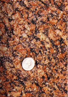 Course grained red Basalt from Aswan
|
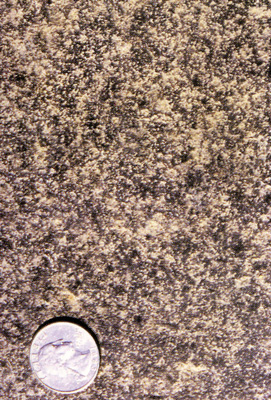 Fine grained Basalt from Aswan
|
|
|
||
|
|
|
Contact & Feedback : Egyptology and Archaeology through Images : Page last updated on 21-November-2025