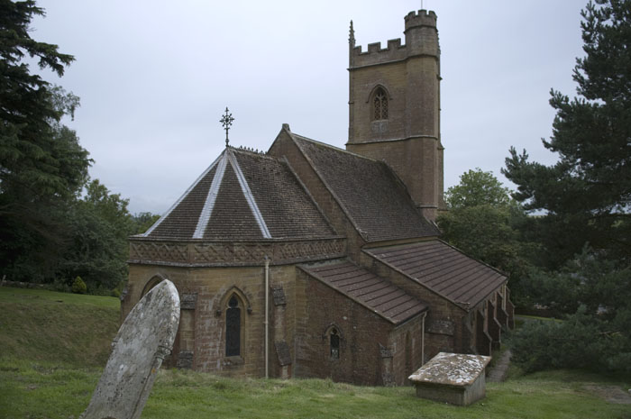
Church of St Andrews, Corton Denham, Dorset
The original Church was demolished in 1869 and
this large building was rebuilt over the site in 18 months and it was funded by
Lord Portman. It cost £2350 to build and the ground-work cost an additional
£335. The fittings added £725 to the total cost and these were donated by the
Rector and his family.
The Stained and painted glass surrounding the altar was executed by Jean-Baptiste Capronnier and is dated to 1870, he produced either of the Churches windows. Jean-Baptiste Capronnier (1814-1891), Belgian stained glass painter, was born in Brussels in 1814, and died there in 1891. He had much to do with the modern revival of glass-painting, and first made his reputation by his study of the old methods of workmanship, and his clever restorations of old examples, and copies made for the Brussels archaeological museum. He carried out windows for various churches in Brussels, Bruges, Amsterdam and elsewhere, and his work was commissioned also for France, Italy and England. At the Paris Exhibition of 1855 he won the only medal given for glass painting.
Corton Denham
The ancient parish of Corton Denham, formerly
Corfetone, lies 4 km. north of Sherborne. The parish was long and narrow in
shape, measuring 4.5 km. from north to south and in breadth varying between 2
km. in the north and 0.5 km. in the south. It derives its name from the narrow
pass in the north at Whitcomb between Parrock Hill (170 m., 558 ft.) and the
Beacon (196 m., 643 ft.) which opens into a valley formed between the dip slope
of the Corton ridge (130 m., 426 ft.) on the west and the steep scrap of Corton
hill rising above 190 m. (623 ft.) on the east. The additional name Denham, from
the Dinham family, patrons of the living 1301-1501, was added in the 1540s.
Corton village lies in the centre of the valley which falls from 119 m. (390
ft.) at the pass to 60 m. (197 ft.) at Stafford's, formerly Stovard's, Green.
Further south, on the lower part of the scarp, is the hamlet of Holway. In 1966
the southern part of the parish, including Stafford's Green and Holway, was
transferred to Sandford Orcas. The ancient parish measured 1,371 a.; the present
civil parish covers 465 ha. (1,149 a.). The Beacon, named from the beacon
recorded in 1627, and the higher parts of Corton hill are of Inferior Oolite.
The scarp and the bottom of the valley lie on Yeovil sands while the dip slope
of the Corton ridge is formed by limestone junction beds. The ridge and its
scarp comprise Pennard sands. Three north-south routes from South Cadbury
towards Sherborne crossed the parish in the later 18th century. South of Corton
village all three met the more northerly of two east-west routes. That was
described as a 'herpath' in the 10th century and continued into Rimpton. The
north-south road along Corton ridge was closed as a highway in 1864.
There are slight traces of Neolithic and Roman occupation, the first in the form of arrowheads found on Corton hill in the late 19th century. Roman coins were found in an urn in 1723. Corton village lies along a north-south route and a back lane on the east side of the valley, spreading 1 km. from North Town (recorded in 1782) to Dairy House Farm. Whitcomb, in the extreme north and settled like Corton by the 11th century, extended into Charlton Horethorne. There is some evidence of shrinkage there in the 18th or the early 19th century. Stafford's Green, 1 km. south of Corton village, was recorded in 1722 and had newly-built cottages in the 1770s. Holway, named from its position on the valley route to Sherborne and Milborne Port and 1 km. south from Stafford's Green, was mentioned in 1327. The Portmans extended and rebuilt many houses on their estate including some in concrete although most were of stone or brick with slate or tile roofs. One cob cottage survived in 1920.
There was a licensed house in the later 18th century. The Queen's Arms opened c. 1861 and was still in business in 1993. The Corton Denham club was disbanded before 1926 and its banner hangs in the parish church. There was a reading room in the village in 1920. In 1641 there were 166 poll tax and subsidy payers. There were said to be 60 houses in the later 18th century but no families 'of note'. In 1801 the population numbered 377, rising to a peak of 494 in 1831. In the early months of 1841 17 people emigrated to Canada, followed by at least 24 in 1842, mainly at Lord Portman's expense and instigation. The population fell steadily to 255 in 1901, then remained fairly stable until 1951. It fell again to 151 in 1971, recovering slightly to 165 residents in 1981 and 213 in 1991.
The Portman Estate originally spanned 270 acres and was acquired in 1532 by Sir William Portman, Lord Chief Justice to Henry VIII. Today the London holdings cover about 110 acres, bounded by Oxford Street and Edgware Road to the south and west, extending east beyond Baker Street and north almost to Crawford Street. The first parts to be developed were Orchard and Portman Streets in the 1750s. Portman Square followed in 1764. It became fashionable, boosted by Montagu House, built for Elizabeth Montagu, a philanthropist, but destroyed in the Second World War. When the seventh Viscount Portman died in 1948 he left an estate valued at Pounds 10 million and subject to estate duty of Pounds 7.6 million. The family had to sell land in Buckinghamshire and Dorset to pay the duty. By 1951 the northern part of the London estate had to be sold too.
From: 'Corton Denham', A History of the County of
Somerset: Volume 7: Bruton, Horethorne and Norton Ferris Hundreds (1999), pp.
101-108. URL: https://www.british-history.ac.uk/report.aspx?compid=18742&strquery=Corton
Denham Date accessed: 03 August 2009.